A dated record of the Killardry road and bank: 3 April aerial imagery, the rainfall before 24 April, and clearly separated later family photographs.
Factual record. No finding of causation or responsibility is made here.
Last updated 2026-09-22.
Timeline
Context and time are not proof of a work date.
BEFORE 24 APRIL 2025
July 2024 — earlier roadside reference; day not established
The family’s retained Google Street View screenshot displays a July 2024 date and vegetation along the roadside. The month label is not an exact capture day. The absence of a visible pipe in that limited view does not establish that no pipe existed. The screenshot is not reproduced here; the link opens the location in Google Street View, where historical imagery can be selected if available.
Source note: Source S1: retained family screenshot. Month-level date only; the link is a location reference, not a guarantee of the July 2024 panorama. Reference.
30 March 2025 — Sentinel-2 landscape context
The supplied Sentinel-2 view provides broad landscape context. Its stated 10 m resolution cannot resolve this narrow bank, the pipe or individual protective measures. It is not evidence of the date on which roadside works began.
Source note: Source S2: family-held Sentinel-2 context image and supplied date. Context only; no works finding is drawn from its pixels.
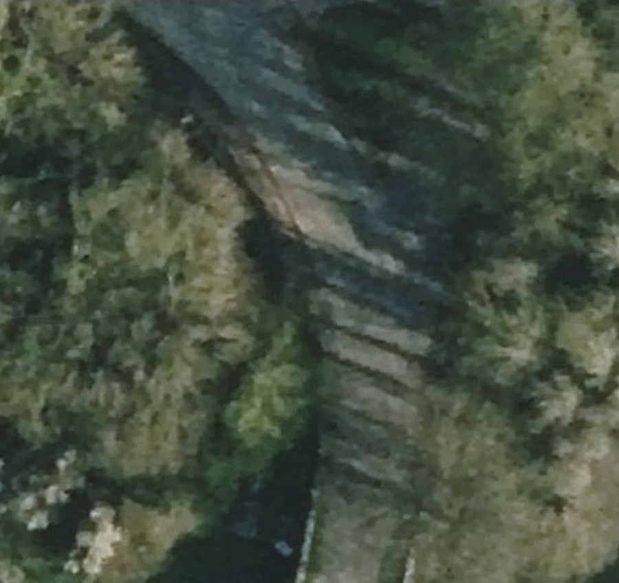
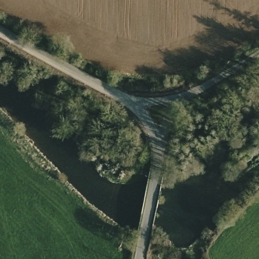
3 April 2025 — aerial image, 21 days before the collision
The Vexcel aerial image records the north-side road and bank before the collision. Lighter exposed-looking ground is visible beside the road. On 21 September 2026, SkyFi explained that the catalogue’s 30 March date was the flight-start date and that the delivered metadata gives the image capture date. That metadata records 3 April 2025. This resolves the earlier catalogue-versus-file date question on the supplier’s explanation. It dates the visible condition, not the start or completion of works, the material’s compaction or the identity of whoever carried them out.
Source note: Source S3: held Vexcel raster and delivered metadata, 2025-04-03T08:44:24Z; SkyFi clarification received 21 September 2026. Aerial photography, not a satellite image.
The family also holds a georeferenced Beijing-3A orthophoto supplied through Apollo Mapping and dated 6 April, 18 days before the collision. The bridge, junction and approach can be located in it. Roadside colour differences and vehicle-like features are leads for examination, not verified machinery, a work crew or a dated works operation. The image is retained privately while the applicable public-display licence is checked.
Source note: Source S4: verified delivered orthophoto; date joined to supplier filename and order records, not an embedded camera DateTime tag. Annotated arrows and vehicle labels are interpretations, not additional observations.
7 April 2025 — catalogue preview only
A SuperView catalogue preview was supplied for a scene dated 7 April. It is a broad browse image, not a delivered full-resolution scene. A product’s advertised resolution must not be treated as the resolution of this preview. No narrow-roadworks conclusion is drawn from it, and it is not reproduced here.
Source note: Source S5: held supplier catalogue preview and quote. Purchase and delivery of the full scene are not established.
DATE OF COLLISION
24 April 2025 — Bronagh’s collision
Bronagh English died on 24 April 2025. Images captured after that date must not be presented as photographs of the road at the time of the collision.
Source note: Source S6: the family’s dated public record. Reference.
AFTER 24 APRIL 2025
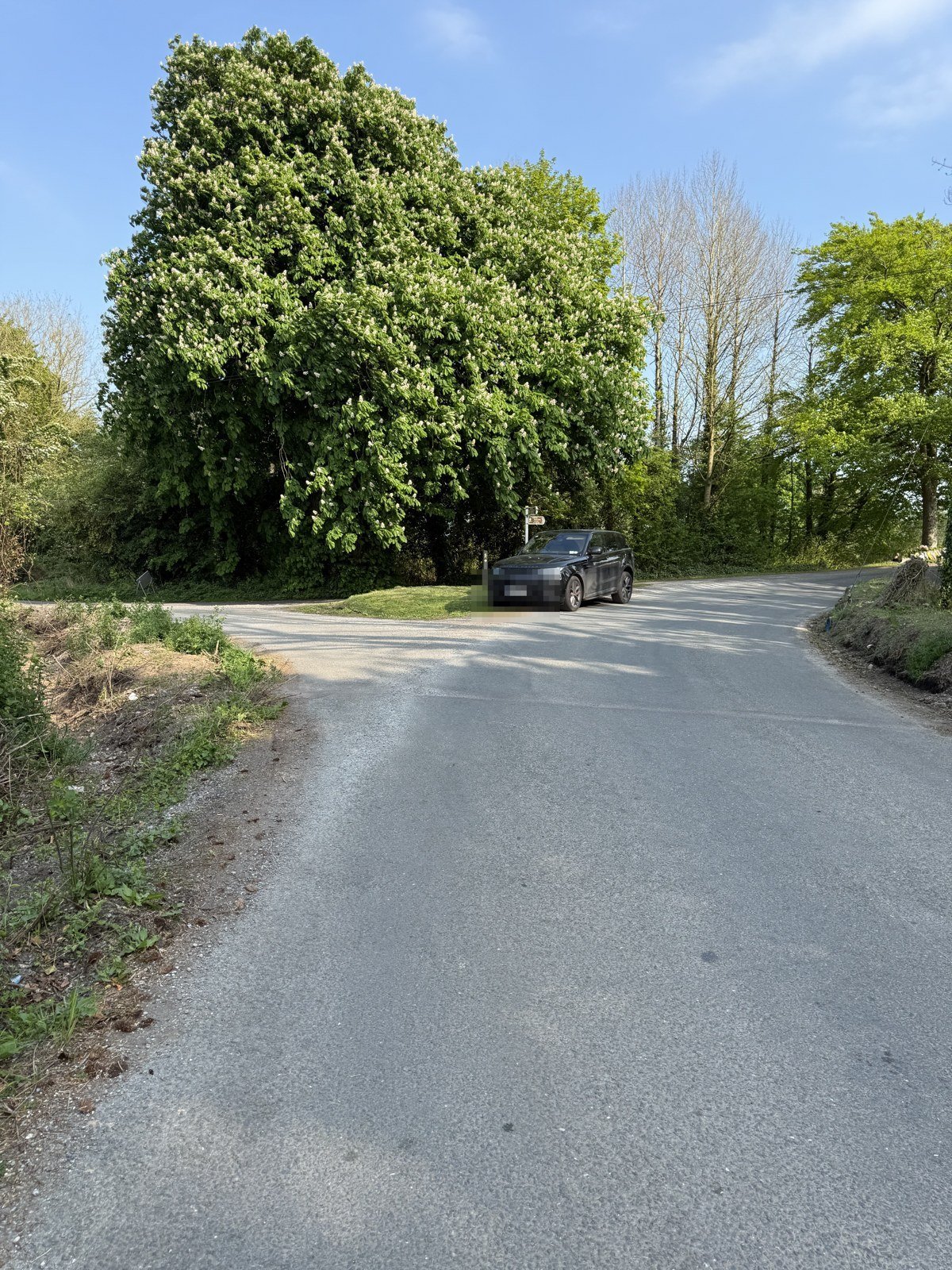
1 May 2025 — later junction and road-edge view
This family photograph shows the junction, roadside vegetation and exposed ground beside the road. The visible junction is the location reference. Left and right here describe the photograph; the view is not used to assert which feature lay on Bronagh’s left as she travelled toward the bridge. The vehicle-registration privacy mask is retained.
Source note: Source S7: family-supplied 1 May record, visually matched to the retained site photographs. Later condition only.
1 May 2025 — AFTER the collision. Junction and road-edge context. The supplied privacy redaction is retained; no reconstruction is shown. Credit: Family-supplied photograph; original preserved.
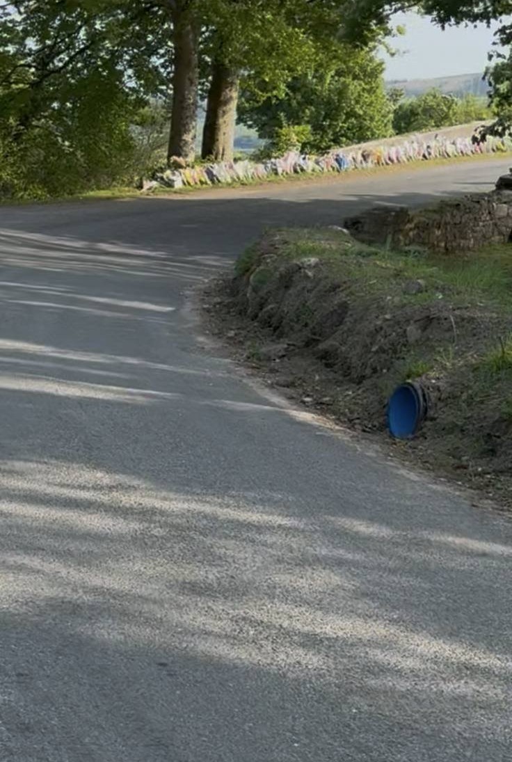
1 May 2025 — later photograph of the pipe and bank
The later family record shows a blue pipe opening beside exposed bank material. The pipe is on the right in this camera view. This photograph does not measure its invert level, gradient, connection or discharge route, and it was recorded seven days after the collision.
Source note: Source S7: family walkthrough, dated 1 May 2025 in the held original record and the supplied screenshot. The displayed crop removes phone controls, not road evidence.
1 May 2025 — AFTER the collision. Pipe and bank context; phone interface cropped away. Image-right is not a finding about Bronagh’s direction of travel. Credit: Family-supplied image; original preserved.
2 May 2025 — held later satellite comparison
The family holds a second Apollo-supplied orthophoto, dated 2 May, eight days after the collision. The supplier’s product record identifies this scene as Jilin-1, not Beijing-3A. It is later site context, not proof of the road’s condition on 24 April. Public display is held pending confirmation of the applicable licence.
Source note: Source S8: verified delivered Jilin-1 orthophoto and supplier order chronology. The complete preferred image file is held even though the wider archive download is incomplete.
Rainfall
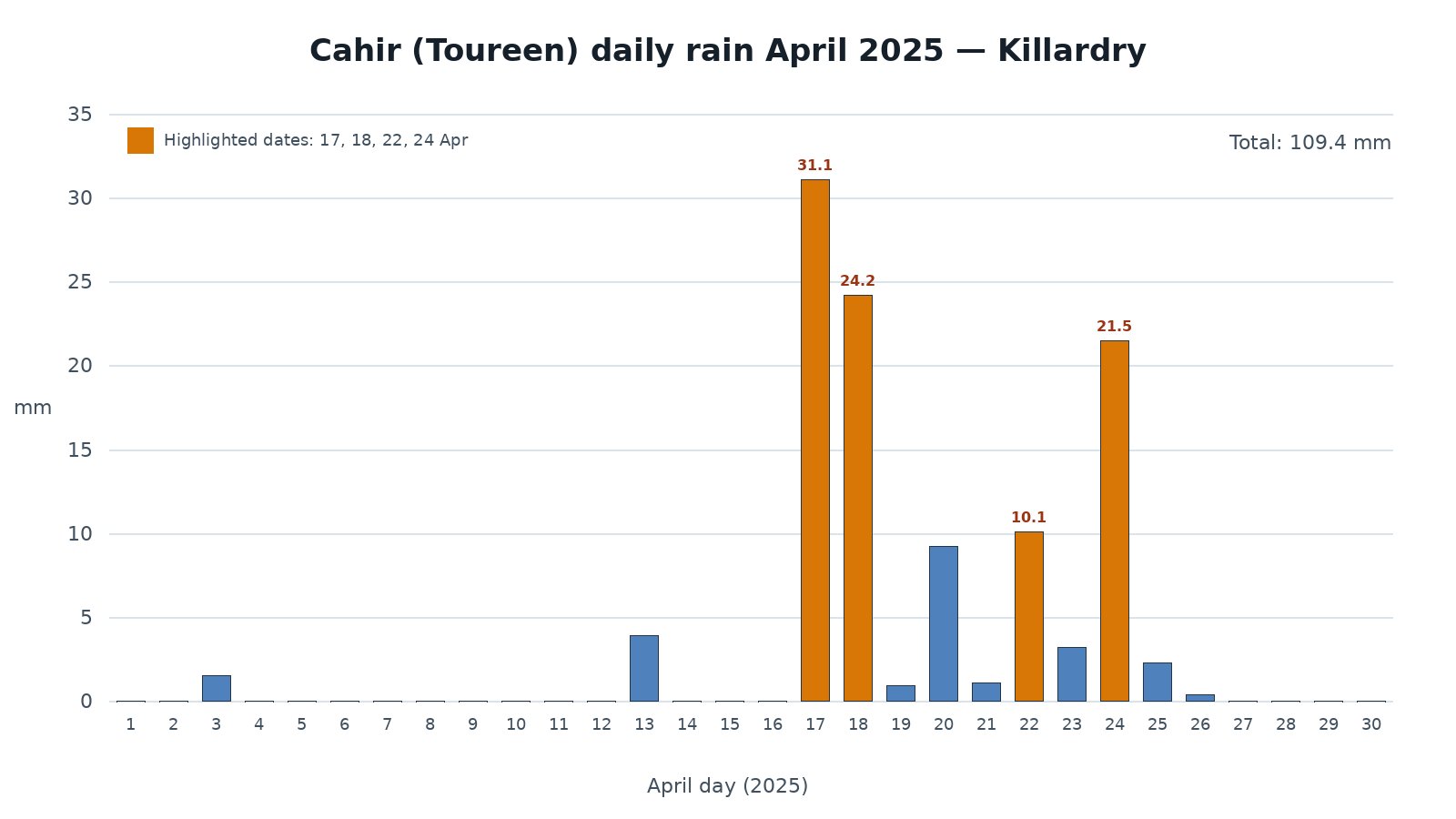
79.8 mm Seven-day pre-collision total: 10:00 on 17 April to 10:00 on 24 April 2025, Irish local time, at Met Éireann’s Cahir (Toureen) station. These are seven 09:00–09:00 UTC gauge days, not midnight-to-midnight calendar days..
21.5 mm next gauge day: 10:00 on 24 April to 10:00 on 25 April 2025, Irish local time. This interval includes rainfall AFTER the collision. The combined 101.3 mm must not be described as entirely pre-collision rainfall. Gauge readings do not measure road flooding, bank saturation, drain performance or grip at the scene.. This includes post-collision rain and must not be treated as rainfall entirely before 24 April 2025.
These are station observations, not measurements of the road, drain, bank, clay, grip or collision conditions.
Whole-month context, not a pre-collision total: April 2025 recorded 109.4 mm. Each label is a 09:00–09:00 UTC gauge day. In particular, the 21.5 mm bar labelled 24 April runs to 10:00 on 25 April in Irish local time and includes post-collision rain. Read the exact seven-day table and windows alongside the chart. Credit: Family-supplied chart using Met Éireann Cahir (Toureen) station 9312 daily observations.
The 3 April image dates a visible pre-collision condition. It does not, alone or by comparison with a summer vegetation view, prove when a particular operation began or finished. Late March and early April remain a period to investigate through dated records.
Needed: Location-specific job cards, gang diaries, works orders, delivery records and contemporaneous site photographs.
What protection and checks were in place?
A limited view cannot establish that no protective measures existed at any time, or whether those measures were adequate. Neither their absence nor their adequacy is established here.
Needed: The traffic-management plan, barriers and signs record, inspection logs and end-of-day checks for the relevant works and dates.
What was the bank material, and was it compacted?
The family describes the exposed material as clay. Photographs do not establish its laboratory classification, moisture content, compaction or condition on the collision night. The rainfall figures are relevant context for examination, not proof of soil movement or a causal mechanism.
Needed: Material specifications, contemporaneous compaction and density records, and qualified geotechnical assessment of what can still be established.
Did the pipe and channel have a working fall?
The blue pipe and roadside feature warrant a location-controlled drainage examination. Their visible appearance does not demonstrate that the pipe had no gravity fall, that an outfall was connected, or that water reached the road. A photograph’s left side must not be substituted for Bronagh’s travel direction.
Needed: A site plan with travel direction, surveyed pipe-invert and outfall levels, drainage drawings and inspection or flow-test records.
Sources
Earlier Street View reference
Family-held screenshot supplied on 22 September 2026, with a visible July 2024 month label. Kept privately; use the Google-hosted view rather than a republished screenshot. The linked guidelines explain display permission, not the image’s date.
Family-supplied context image dated 30 March 2025. A low-resolution landscape reference, not a roadworks measurement.
Vexcel capture date and display extract
The original georeferenced Vexcel raster is held privately. Delivered metadata records 3 April 2025 at 08:44:24 UTC. SkyFi’s reply received 21 September 2026 explains the 30 March catalogue date as flight commencement and the delivered metadata as the capture date. Public display uses a static extract with provider credit, not the full raster or private correspondence. The linked FAQ addresses display permission; the capture-date evidence is the family-held metadata and supplier reply.
Complete preferred orthophoto held and integrity checked. Product date is supported by supplier filenames and order chronology. Public-display licence confirmation remains outstanding; the raster, annotations and confidential commercial records are not published.
7 April SuperView catalogue record
Supplier preview and quote held privately. No assertion of full-scene purchase, delivery or native preview resolution.
Bronagh’s dated public record
The family’s public record gives 24 April 2025 as the date of Bronagh’s death.
Family records dated 1 May 2025. The supplied images are visually matched to the held site record; the screenshot’s date display is not treated as independent embedded camera metadata. Phone controls are removed only in a labelled display crop and existing registration redaction is retained. Original evidence remains unchanged.
Complete preferred orthophoto held and integrity checked. The supplier product record identifies Jilin-1. This is post-collision context and is not publicly reproduced pending licence confirmation.
Met Éireann Cahir (Toureen), station 9312
Daily gauge observations dated 17–23 April sum to 79.8 mm. The following 24 April observation is 21.5 mm and extends past the collision. Met Éireann assigns a 09:00 UTC observation to the preceding date.